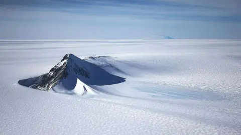
A new map has unmasked the landscape beneath Antarctica's ice in unprecedented detail, something scientists say could greatly enhance our understanding of this frozen continent.
Researchers used satellite data and the physics of how Antarctica's glaciers move to work out what the continent might look like beneath the ice. They found evidence of thousands of previously undiscovered hills and ridges and say their maps of some of Antarctica's hidden mountain ranges are clearer than ever before.
While the maps are subject to uncertainties, the researchers believe the new details could shed light on how Antarctica will respond to climate change - and what that means for sea-level rise.
It's like before you had a grainy pixel film camera, and now you've got a properly zoomed-in digital image of what's really going on, said Dr. Helen Ockenden, the lead author of the study.
In the past, scientists had relatively limited knowledge about Antarctica's topography, with more information available about the surfaces of other planetary bodies in our solar system. The newly constructed map represents a significant leap forward in understanding what lies beneath the ice, revealing detailed features including a deep channel in the Maud Subglacial Basin.
Antarctica's ice is up to three miles thick in places, and traditional measurements were often spaced too far apart to capture the complete picture. The new mapping approach takes advantage of satellite data and physics to calculate something akin to observing the shape of a riverbed from the surface.
The researchers expect that this newfound knowledge will lead to improved computer models predicting how Antarctic ice might behave in a warming climate. Understanding these geophysical features is crucial because they directly affect glacier dynamics and possible contributions to global sea-level rise.
The findings were published in the academic journal Science, marking a notable step in Antarctic research.