As Erin's wind speeds surged from 100 mph to 160 mph within hours, experts highlighted this rapid intensification as a concerning trend influenced by global warming. The storm is expected to move gradually northward next week, passing near the Bahamas and approaching the Outer Banks of North Carolina. The east coast of the US is bracing for hazardous surf and rip currents, with Florida and mid-Atlantic states at the highest risk. Moreover, the US Coast Guard has enacted restrictions for vessels at ports in the US Virgin Islands and parts of Puerto Rico, while NOAA warns of an “above normal” hurricane season ahead.
Hurricane Erin Strengthens to Category Five Ahead of US East Coast Impact
Hurricane Erin Strengthens to Category Five Ahead of US East Coast Impact
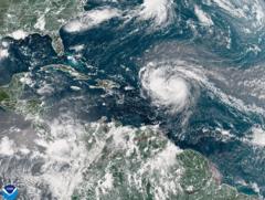
Hurricane Erin has rapidly intensified into a powerful category five storm with damaging winds, threatening life and property along the US East Coast.
Hurricane Erin, the first major storm of the 2025 Atlantic hurricane season, has escalated into a category five storm with maximum sustained winds reaching 160 mph. Highlighted as "extremely powerful" by National Hurricane Center Director Mike Brennan, Erin transitioned from a tropical storm overnight on Friday. The hurricane is expected to pass north of the Leeward Islands, Virgin Islands, and Puerto Rico throughout the weekend, bringing significant rainfall, flash flooding, and mudslide risks. Currently, it is not predicted to make landfall on the US mainland.


